Morning 4 came with a degree of anticipation – for one thing, I was finally leaving Souillac and moving into the heart of the big pointy peaks, and for another, I was about to have a crack at the peak I wanted the most – Rempart.
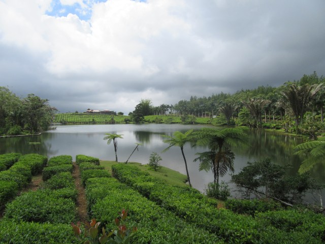
I didn’t need an early start on this day as Bois Cheri Tea Factory only opens around 9am anyway, and that was my first stop of the day.
Saying goodbye to the south side of the island wasn’t exactly difficult. It had been really great, but I had done what I came here to do and really had no reason to want to stay around there any longer.
I arrived at Bois Cheri just over half an hour before the first tour, so I spent some time walking around the museum. The history of the company was fascinating to read up on.
The tour of the factory was very interesting, although on the short side.
The tea tasting was good. I ended up joining a group of people from England for this. Turns out the group was on a guided tour, and the lady who runs the company was personally leading this tour as her father was one of the tourists. They invited me to join them for the rest of the day, which I agreed to do.
We proceeded from here to Grand Bassin, which I had already visited, but this time I had some guidance on what I was looking at.
Unfortunately I ended up losing them when we were moving from the crater to the large statues, so I continued along with my solo travels.
Trou aux Cerfs was next on my to-do list, so I proceeded along.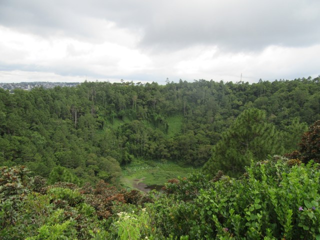
Trou aux Cerfs is a large volcanic crater. It is around 80m deep, it looks like there are a few places where you can go into it, but I decided not to. Officially you aren’t allowed in. I walked the entire way around it before deciding to head off for what I really wanted to do – Rempart.
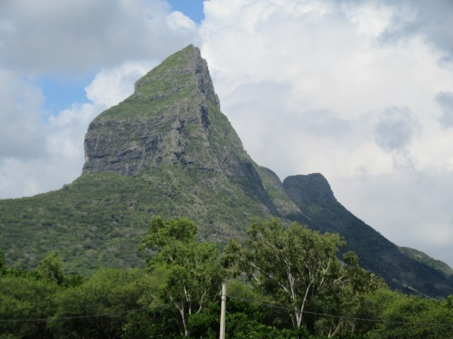
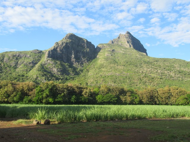
Some background on Rempart, seeing as there is basically nothing online:
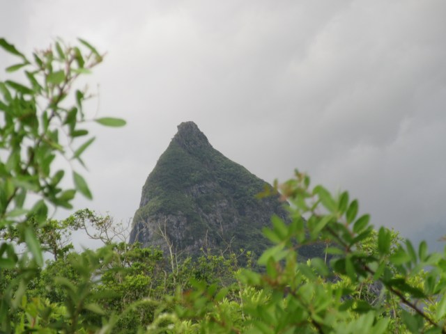
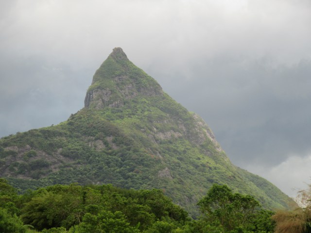
– It is one of the highest summits on the island
– It is sometimes called “the Mauritian Matterhorn”
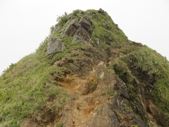
– It is ascended by a via ferrata on the west ridge
– There is practically no information on how to get up online, baring a youtube video from 2006 showing a team ascending it
When I first saw it, I knew I had to climb it. It just looked too terrifying not to try!
Seeing as my extensive research had told me very little about access to the peak, I started by trying to get as close to it as I could with my car. After a few dodgy roads, I found a spot where I could park and continue on foot.
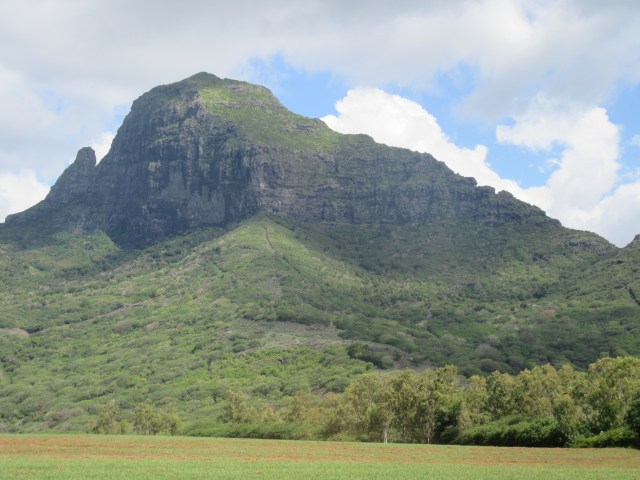
I walked around a bit, until a large fence informed me that I had run out of options in that direction. On the bright side, I could see the via ferrata was still there, when I used zoom on my camera.
I went back to my car and decided to try a line more to the south. I had found a GPS track that started around there, so it seemed like the best bet.

This side provided more dramatic views, but still a large fence stood between me and the peak.
It was getting late, I hadn’t planned to head up on this day anyway – I just was hoping that I would know where to start when I try it tomorrow. After all, I had ropes and some light climbing gear for my actual attempt, and I wasn’t carrying that with me.
I found a local restaurant and had a really nice plate of chicken fried rice for supper. I asked the owner if they know how to get up, and they asked around and couldn’t get anything helpful either. I was starting to get the message here – this really isn’t something that is open to the public.
I could tell I was closer to the city – it was around 4pm and traffic was getting much heavier than I had seen on the island so far. I stopped at a local shopping centre and bought some hiking food, tea bags and a few other items I needed.
I checked into my accommodation in Quatre Bornes, incidentally the place was called “Mountainview” – which seemed fitting. It is actually a really beautiful part of the island. It is also far enough inland that the humidity isn’t quite as bad, although it is still very bad. It was also the first place I stayed at that had a sign outside and a reception, so for once I didn’t spend an hour trying to figure out how to check in or find the place.
That evening I watched the 2006 video of the via ferrata again. I was very nervous – I knew bailing was easy, but do I want to bail because I’m scared, or do I want to bail because I am experienced at mountain climbing and know this is unsafe?
So I sent the video to my good friend Andrew – who is a far better mountain climber than I am. He provided me with an opinion that it looks fine as their is adequate redundancy – and in signing off, gave me my favourite reply ever: “and if it does fail, it is a quick ride into a messy diplomatic incident that will make front page news. So, your Mom will know why you are not answering your phone”
I had kind of been hoping for an answer along the lines of “you don’t know how good the anchors are, so best to stay safe” – but the reason I asked Andrew was I knew that he wouldn’t give me an answer like that unless he genuinely thought that was the case.
The evening, I saw a link to Ryan Sandes and Ryno Griesl’s new feature “Lessons From the Edge”. In the video, Ryno said something along the lines of “bailing is easy, but you always regret it later” – and I realised how true that was for the day that was going to dawn.
So I packed my bags and got to bed nice and early, in anticipation of the big day.
Day 5
Having seen exactly where they started the ascent on the 2006 video, I knew were I wanted to go. I was in my car by 6am to avoid early morning traffic.
I parked my car on the side of the road and began walking through the nearby farm. It was a beautiful morning.

I crossed a large stream – surprisingly wide for something that isn’t very deep – and tried a network of trails on the far side.

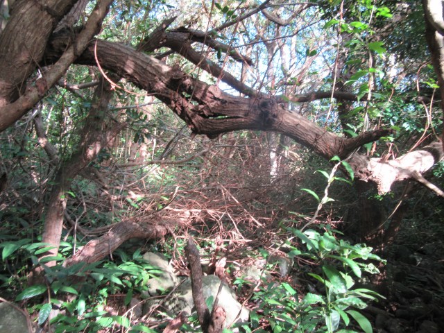
Every trail I attempted soon died in a mess of overgrowth.
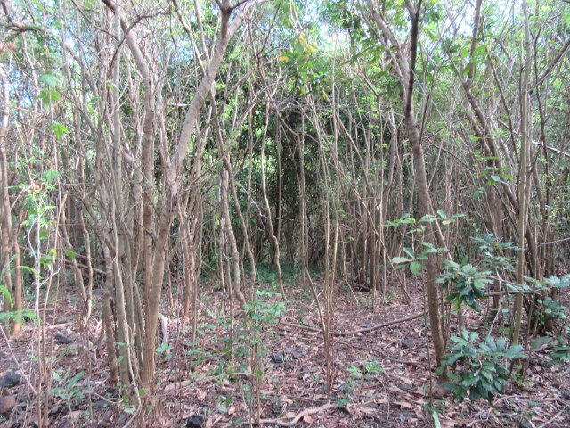
I systematically worked through all the trails I could find until they died, and then reversed back to the main trail to try the next turnoff.
Eventually, after roughly 2 hours of searching, and once feeling like I was getting nice and close when I actually managed to get above 400m in altitude, I eventually ran out of trails to try – when my last prospect ended at a large locked gate.
Walking back, I couldn’t help wondering if I should have just pushed through the overgrowth till I was in lighter terrain and tried to go from there. But aside from how unpleasant that would be, it is also a bit dangerous – especially when I have to come back. Further to which, if something goes wrong – I don’t have a phone number to call for help, and in an injured state, I won’t make it back to my car through dense overgrowth – so I guess sometimes you just have to accept defeat.

I had considered climbing Corps de Garde (the 720m peak just north of Rempart), but decided I would rather go for Le Pouce in order to reduce pressure on tomorrow’s hiking plans – which also included Pieter Both Mountain.
At the time I was wondering if I really tried as hard as I could have to find a line up Rempart – even with 12km of exploration hiking and over 6 hours total exploration time between the evening before and this morning. I guess one always ends up second guessing themselves in situations like that.
Le Pouce is very commonly climbed by locals, but rarely by tourists. There isn’t much parking at the base, so I had to park about 500m down the road from the trail head.
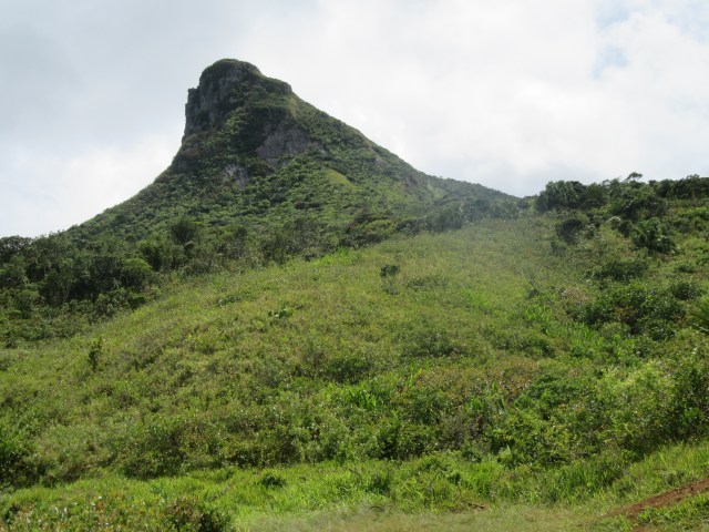
The peak is surprisingly steep and pointy, and incredibly impressive in person. It is hard to capture the shape in photos.
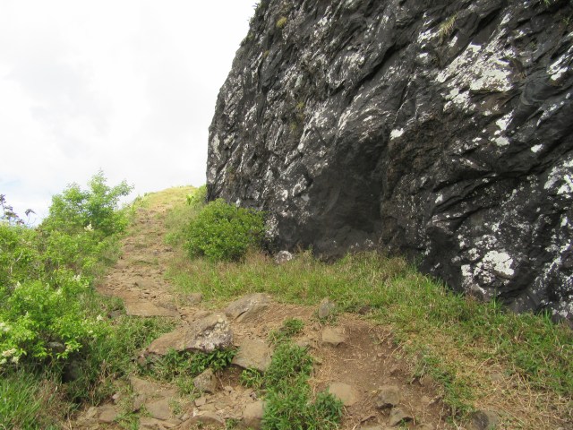
The trail is very wide and easy to follow. It winds its way through the lower cliff line before reaching a plateau where the final large pointy bit is found. The final stretch has a bit of easy scrambling and the summit has a massive drop off on either side.
Mist came over as I reached the top, which was a bit annoying – but I had seen most of the view from lower down, and Pieter Both would provide a similar view the next day – seeing as the peaks are only a short distance apart.

I had a chat with some locals on top before heading back down. I would have tried to wait out the mist if I wasn’t about to run out of water.
As I descended, the mist cleared.
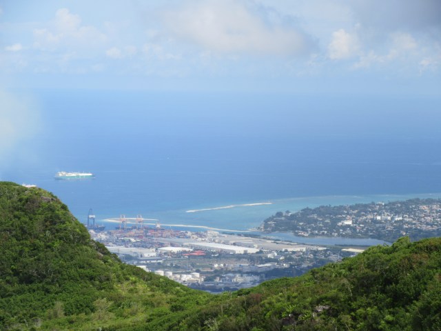
After the ascent, as it started to rain, I made my way into the capital – Port Louis.
The capital is below the peaks of Le Pouce and Pieter Both, and having them tower over the city gives it an interesting feel. My only goal in the city was to visit the waterfront and get some lunch. I had to visit to capital – how can I tour a tiny island nation and ignore their capital? But it wasn’t somewhere I wanted to spend a lot of time.
The parking at the waterfront was very difficult to get into – and as I was about to get out of my car, I heard my camera crashing to the floor. The camera still works, but the LED display at the back is broken.
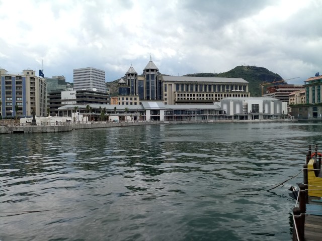
I found something to eat, although the waterfront was very expensive, and had a general look around. To be honest, the one at Grand Bay is more worthwhile.
I proceeded from here to Pamplemousses Botanical Garden. My brother and his wife had both rated this very highly, so I was expecting a lot.

The gardens were very large and had a fairly reasonable number of caged animals – not something I like to see.
The displays were exceptional, but there was plenty of space to disappear. I was quite tired and eventually found a tree in the middle of nowhere where I could sit for half an hour and chill.
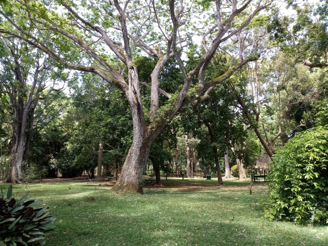
This form of Botanic Gardens always feels very artificial to me. Nature doesn’t look like this, well, not in my experience anyway. But it was still nice to have a place to sit and do nothing. The more central areas were very crowded, especially considering it was a week day.
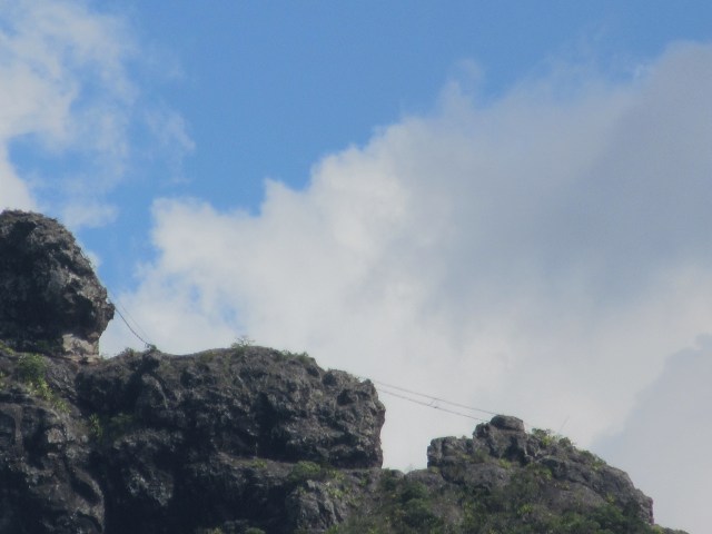
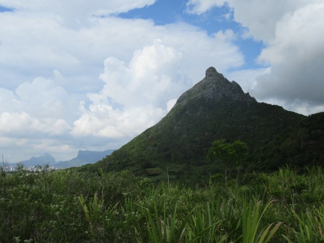
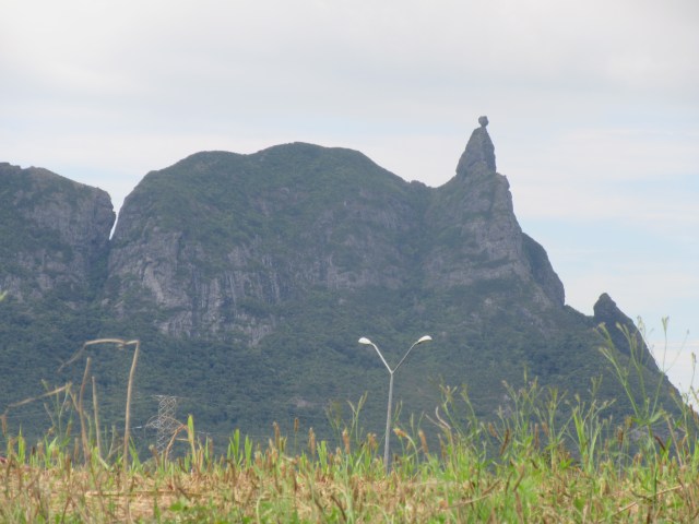
It had been a long day, and even though it was still fairly early, I decided to head back to where I was staying. On the drive back, along a very nice dual-carriageway, I got a great view of Pieter Both – so I stopped to get some photos. Not that photos do it any justice at all! The point of the summit looking like a person’s head actually made sense from this angle.
The place I was staying at was close to a large shopping centre, so I found a few local snack foods to try, including a very baked nice coconut rice sweet – before opting for a roti and curry for supper.
While missing Rempart was a big disappointment, the rest of the day had been pretty good – baring the incident with the camera, and a near miss while driving when someone stopped to let a passenger out in the middle of a traffic circle and I almost rear-ended them. Luckily the breaks on my car were in good working order!

Excellent photos–thank you for sharing!